Desarrollo Espacial-Ad Astra
Artículo de investigación
Ciencia y Poder Aéreo | vol. 16 n.º 2 | julio-diciembre del 2021 | pp. 46-59 | ISSN 1909-7050 E-ISSN 2389-9468 | https://doi.org/10.18667/cienciaypoderaereo.732
Satellite Systems for Colombian Space Development with Multi-domain Operations *
Sistemas de satelites para el desarrollo espacial de Colombia a través de operaciones multidominio
Sistemas de satélite para o desenvolvimento espacial da Colômbia por meio de operações de múltiplos domínios
Fecha de recibido: 8 de septiembre del 2021 | Fecha de aprobación: 17 de octubre del 2021
Germán Wedge Rodríguez Pirateque
MSc in Mechanical and Mechatronics Engineering
Julián Camilo Páez Piñeros
Mechatronics Engineer
Jorge Sofrony Esmeral
PhD in Control Systems
Resumen:
El desarrollo de las zonas rurales de Colombia y su conexión con las áreas urbanas ha sido uno de los grandes desafíos para garantizar una presencia efectiva del Estado en el territorio. Como parte de las alternativas para potenciar el desarrollo integral de la infraestructura y las comunidades rurales, se han propuesto opciones para la prestación de servicios aeroespaciales que ofrecen medios de comunicación permanentes y herramientas para la observación terrestre, asistencia ante los efectos de fenómenos climáticos, cuantificación demográfica, control de áreas y poblaciones, y la determinación de rutas y vías de acceso, entre otras. A partir de ello, se propone una metodología para el análisis, diseño, desarrollo, implementación y evaluación de un proyecto espacial, que incluye el cálculo de condiciones operacionales y elementos orbitales, parámetros de desempeño, áreas de cobertura, número de aviones y satélites, y varios modelos de constelaciones de satélites dentro del territorio nacional. Esta propuesta busca identificar diferentes alternativas para el diseño y uso de equipos satelitales, con el fin de formular planes estratégicos a nivel estatal que permitan la apropiación de las tecnologías aeroespaciales, ofreciendo servicios equiparables al nivel de acceso a las comunicaciones y la observación terrestre, como medio para la planificación de políticas públicas orientadas a mejorar la conectividad y las capacidades tecnológicas de Colombia.
Palabras clave: diseño de constelaciones; cobertura regional; redes de nanosatélites; agentes heterogéneos.
Abstract:
The development of regions in rural areas and their connection with urban areas in Colombian territory has been one of the great challenges for an effective presence of the state. Different alternatives have been proposed for the provision of aerospace services that offer means for a permanent communication and tools for terrestrial observation, as well as support against the effects of climate phenomena, demographic quantification, the control of areas and populations, the determination of routes and access roads, among other alternatives that enhance the comprehensive development of communities and their technological infrastructure. Based on this, we developed a support methodology for the analysis, design, development, implementation and evaluation of the presented design process, which includes the calculation of operational conditions and orbital elements, performance parameters, coverage areas, number of planes and satellites, and different models of satellite constellations within the national territory. In order to provide different alternatives for the design and use of satellite equipment with useful information for the structuring of State-level strategic plans that allow the appropriation of aerospace technologies and provide services comparable to the level of access to communications and ground observation, as the means for planning public policies aimed at enhancing connectivity and technological capabilities in Colombia.
Keywords: constellation design; regional coverage; nanosatellite networks; heterogeneous agents.
Resumo:
o desenvolvimento do meio rural na Colômbia e sua vinculação com o meio urbano tem sido um dos grandes desafios para garantir uma presença efetiva do Estado no território. Como parte das alternativas para promover o desenvolvimento integral das estruturas e comunidades rurais, foram propostas opções para a prestação de serviços aeroespaciais que ofereçam meios de comunicação permanentes e ferramentas de observação terrestre, assistência aos efeitos dos fenómenos climáticos, quantificação demográfica, controle de áreas e populações, determinação de rotas e vias de acesso, entre outras. A partir disso, é proposta uma metodologia para a análise, concepção, desenvolvimento, implementação e avaliação de um projeto espacial, que inclui o cálculo das condições operacionais e elementos orbitais, parâmetros de desempenho, áreas de cobertura, número de aviões e satélites e vários modelos de constelações de satélites no território nacional. Esta proposta busca identificar diferentes alternativas para o desenho e uso de equipamentos de satélite, a fim de formular planos estratégicos em nível estadual que permitam a apropriação de tecnologias aeroespaciais, oferecendo serviços comparáveis ao nível de acesso às comunicações e observação terrestre, tais como meios para o planejamento de políticas públicas destinadas a melhorar a conectividade e as capacidades tecnológicas da Colômbia.
Palavras- chave: desenho de constelação; cobertura regional; redes nanossatélites; agentes heterogêneos.
Earth observation and monitoring through the capture of images are highly significant for risk management and, especially, the provision of useful information related to territorial organization processes and the deployment of capacities to rural areas and remote regions. The development of tools for the monitoring and surveillance of the territory seeks to support high-level decision-making (Rouff & Truszkowski, 2001). For example, satellite systems facilitate the evaluation and development of contingency plans against climate change and its associated risks to different sectors of the country. Likewise, the environmental impact of certain activities (e.g., illegal mining) over our natural resources, such as water sources, natural reserves, and biodiversity, can be actively monitored (Schilling, 2017).
Consequently, the development of an aerospace culture associated with the development of capacities, in particular the design and development of networked satellite systems, such as constellations with low-cost satellites (Yoon et al., 2014), will significantly contribute to the sustainable use of resources and the protection of Colombian society (Corredor-Gutiérrez, 2017; Rodríguez-Pirateque et al., 2020; Ximenes et al., 2019).
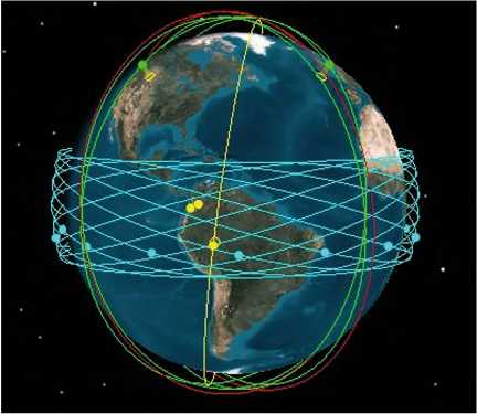
The alternatives for the access to space through democratization and the new space concept have opened paths for the design of strategies and the search for solutions to connectivity needs and the presence of governments in remote areas of the country (Álvarez-Calderón et al., 2019). In this sense, different proposals for the use of space technologies have been presented, such as the constellations of satellites (Alvarez & Walls, 2016; Del-Portillo et al., 2019; Mingqi et al., 2016), which allow solving multiple needs and, in turn, provide tools for the collective development of the country. Given this, the biggest space agencies of the world have based many of their technological developments on the support of satellite systems, such as the services provided by GPS (Allende-Alba et al., 2017), GALILEO, GLONASS, and Copernicus, among others, as well as on the recent process of satellite internet implementation through the Starlink constellation, developed by SpaceX (McDowell, 2020), as shown in figure 1
Figure 1. Starlink Constellation by SpaceX.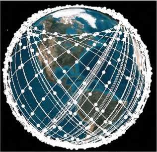
Source: authors.
With the advancement of new private actors, the integration of technologies such as the Internet of Things (IoT) (Prescornitoiu & Morales, 2019; Qu et al., 2017), the management of big data and, more significantly, new materials, with the implementation of Microelectromechanical systems (MEMS) (Kvell et al., 2014; Shahzad-Shaikh et al., 2018), satellite systems have evolved into networks of small satellites that can be more eligible for national-scale space projects.
Against this, extensive research has been developed to offer different scenarios for the use of these technologies (Fugmann & Klinkner, 2020), as is the case of multipurpose networks (Barakabitze et al., 2020; Saeed et al., 2020), support systems, and even sensing and data processing capabilities that facilitate the use of aerospace services (Mingqi et al., 2016).
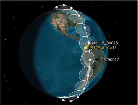
Taking as a reference the first evidence of space projects in Colombia, Libertad 1 satellite and FACSAT1 are shown in figure 2, displaying their respective planes and orbital conditions. These satellites are the materialization of the efforts and initiatives to reach space resulting from the advances offered by the democratization of space (Rodríguez-Pirateque et al., 2020a, 2020b; Schaub & Junkins, 2009). According to the above, this article proposes design network satellite systems as a strategy for the coverage of areas and difficult-access territories, as part of the proposal for the provision of communication and ground observation services in the face of Colombian regional aerospace development.
Figure 2. Libertad 1 and FACSAT1 satellites.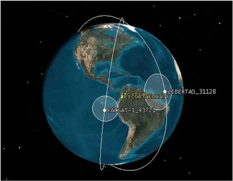
Source: authors.
For the development of these purposes, this article is organized as follows. The section after this introduction presents the problem statement, which seeks to evaluate the impact of capacities constellations. The next section describes the composition of constellations design. Afterwards, we address the application of the constellation proposals designed to meet regional needs and coverage in Colombia. The last section presents the conclusions and recommendations for future works on the subject.
It is worth mentioning that our simulations were made using both MATLAB R2018a Software and AGI STK 11 software, under an educational or free license.
Methodology
The project was carried out following a design methodology for the technological management of engineering projects (ADDIE) (Rodríguez-Pirateque, 2017), which starts from the study of the needs and requirements identified in the process based on five phases: analysis, design, development, software implementation, and evaluation of the functional and logistical alternatives that provide support to the connectivity and scope of aerospace technologies across different regions of the country. The method is based on a functional review, the structuring of algorithms, and the fine-tuning of modeling means that illustrate both the characteristics and the operational requirements of the proposed networks (Bandyopadhyay et al., 2015; Burleigh et al., 2019).
In each phase, the objectives of the mission are proposed, and the analyzes and designs of the constellations that can supply the required services are displayed, detailing the parameters and simulations that model the intended proposals (Lansard et al., 1998).
Constellations Design Process
The process for the design and configuration of satellites in orbit (Lansard et al., 1998; Lo, 1999) starts from the need to identify variables and specific parameters that illustrate the operation of constellations in different flight conditions, such as the number of satellites and orbital planes required, the characteristic orbital elements (figure 3), or the specifications in spectral, radiometric, temporal or spatial resolution demanded by aerospace services.
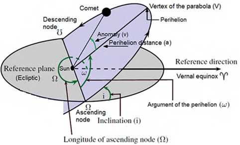
Source: Bistafa (2021).
Table 1 presents a set of definitions to provide the reader with a better understanding of the concepts addressed in this document.
Table 1. Relevant definitions.
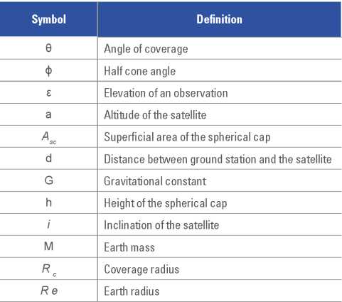
Source: Wertz (2012).
Main Design Method
This method uses the following equations to calculate the coverage radius and the half cone angle (Fugmann & Klinkner, 2020), which is represented as the φ angle in figure 4. The known values are: ε, Re and A. This creates a triangle of sides Re, d, Re + α (Mingqi et al., 2016).
Figure 4. Trigonometric relationship between the different elements of the Walker Method.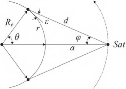
Source: Prescornitoiu and Morales (2019).
Using the law of sines to solve this triangle, we formulate equation 1:
which can be solved for φ to obtain the half cone angle, as shown in equation 2.
Also, the coverage angle can be calculated using equation 3:
With this, the coverage radius is calculated as a terrestrial arc length:

Satellite footprint
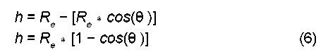
Another useful application for the coverage radius is to find how much area can the satellite fully cover. In order to achieve this, it is necessary to know the definition of a spherical cap, which is shown in figure 5 as the result of intersecting a sphere with a plane.
Figure 5. Sphere section or spherical cap.
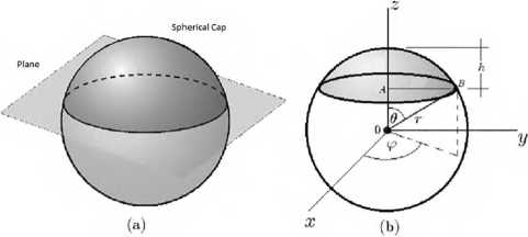
Source: Soldovieri and Viloria (2016).
Now, the superficial area of this spherical cap is the coverage area of the satellite shown in figure 4. This area can be calculated with equation 5, in which Asc represents the superficial area of the spherical cap, Re is still the radius of the Earth, and h the height of the spherical cap.
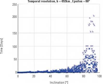
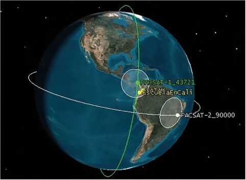
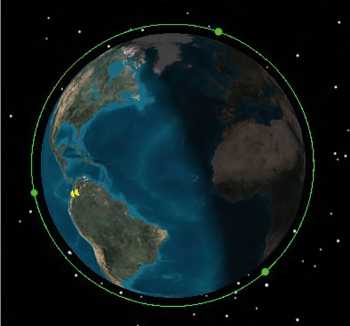
It can be inferred from figure 4 that h is just as it is represented in equation 7, where θ is the same as in equation 3: Resulting in equation 7 in order to find the superficial area of the spherical cap. Looking for a way to calculate the time it takes a satellite to be on the same spot relative to Earth the following simulation has been created. First, the speed of the Earth is taken into account to move a point in a circular motion according to this variable, which can be solved for φ to obtain the half cone angle as shown in equation 2 this point is the target location on the surface of the globe. Then, the speed of the satellite is also required, and it has to be decomposed on the direction of rotation of the Earth and another direction perpendicular to this movement. After that, the simulation runs one second per iteration, time in which the position of the satellite and the target location are calculated. Finally, in each iteration the angular distance between these objects, the satellite and the target, is calculated. When this number is lower than θ (equation 3), revisit is achieved, and the number of iterations calculated so far is the time (in seconds) that the satellite took to revisit the same location twice. There are two kinds of revisit: an oblique revisit and a nadir revisit. The first one is when the satellite is just in range for communication purposes, that is, its elevation for the observer or the receiving antenna is at least 20° (ε = 20°). The second, when the satellite is at least at an elevation of 80° (ε = 80°). Next, this simulation is repeated with a satellite with an inclination that varies from i = 0° to i = 100°. The results for the two kinds of revisits are shown in figures 6 and 7. Figure 6. Revisit with ε = 20°. Source: authors. Figure 7. Revisit with ε = 80°. Source: authors. The development of Colombian regions through space technologies demands a set of strategies. Among them, various alternatives for territorial coverage with ground observation missions and communications will be presented below. The main objectives of missions lie in the provision of communication services for remote areas and the capturing of images for registration, surveillance, control, and territorial planning, which provide tools for the deployment of public policies and government programs capable of linking the needs of regions (Roscoe et al., 2018). First, the FACSAT1 satellite system is presented, an equipment that is operationally active and in use by the Colombian Air Force, from the Aerospace Technology Research Center (CITAE), and that is complemented by the projection of FACSAT2, which is in the process of mission design and represents the most recent solutions in the democratization of space by the Colombian state. Later, a projection of what would be a constellation with complete coverage in different orbital planes is presented. Some alternatives in the design of constellations include the calculation of satellites located in a single orbital plane, in order to cover a linear perimeter in the orbit (figure 10). Figure 10. Lineal constellation. Source: authors. There is also a multipurpose constellation with communication and observation equipment, which can be configured with different numbers of satellites, planes, and orbital inclinations, adjustable to the progress and results of the analysis of enabling conditions and requirements established by CONPES 3983/2020 of the Colombian spatial development policy. As special alternatives, two revolutionary designs known as satellite formations are presented in the satellite context. The first formation has a number of in-flight agents capable of carrying out coordinated and cooperative missions, while the second alternative counts on different satellite clusters or grouped formations, in different orbital planes, for super-resolution image objectives and even elevation models, thanks to configurable network architectures that can be developed in these formations. Finally, an integrated system between space, air, land, maritime and cyberspace means is proposed. This system seeks to develop multidomain missions capable of interconnecting the different domains and capacities for specific objectives that project the integration of structures and services, with the purpose of accomplishing operations and meeting the needs of the Colombian territory. Colombia currently has within its satellite inventory the FACSAT1 type 3U, with RGB camera of 30m/pixel with the current TLE, and the FACSAT2 type 6U, with 5m/pixel, each in a different orbit (figure 8). Figure 8. FACSAT Space Program. Source: authors.
Temporal Resolution Analysis
Regional Development Strategies by the Network
Current Satellites of the Colombian Space Program
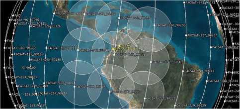
Full Coverage Constellation
In order to have a constellation with at least one satellite at a given time on a given location some conditions must be met, these conditions are as follows:
- A polar constellation to cover all the latitude range over the world.
- A number of orbital planes enough to cover all the longitude range all over the world at any time;
- A number of satellites in each orbital plane to cover the whole orbital plane at any time.
To achieve this, a MATLAB script was created to calculate these 2 figures. This script creates a TLE file with all the satellites in the constellation, and has the following inputs:
- The altitude of the satellite.
- The inclination of the polar orbit.
- The minimum elevation of the satellite for the observer, depending if the satellite is used for observations (80°) or communications (20°). This is used to calculate the half cone angle, which is then used to determine the number of satellites in an orbit and the spacing between orbits.
- Altitude: same as FACSAT1.
- Inclination: same as FACSAT1.
- Minimum acceptable elevation to link: 20°.
- In order to acquire the two first inputs, the script downloads the TLE file for the FACSAT1 and extracts the required information.
In this case study, the inputs are:
It is worth noting that to have full coverage in the middle points between orbits, all the constellation needs to be inclined with respect to the rotation axis of the Earth so that there are no gaps between coverage regions, as shown in figure 9.
Figure 9. Full coverage constellation scheme.
Source: authors.
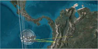
The results are provided in the following list and in figure 9, where 6 Satellites are shown on coverage over CATAM airport, Colombia.
- Altitude: 490,3671 km
- Inclination: 97,4135°
- Minimum acceptable elevation: 20°
- Orbital planes: 14
- Number of satellites in each orbital plane: 27
- Total number of satellites: 378
Lineal Constellation
Multi-agent Systems Mission (SMA1). Proposed under the name of "Arpía," its purpose is the realization of multi-image shots, counting on the fact that the goal is to operate as a homogeneous or hybrid constellation for taking images under continuous scanning or a discrete perspective in a single orbital plane, with full coverage of the orbital circumference or perimeter by configuring network satellites with optical sensors or Synthetic Aperture Radars (SAR) (figure 10).
The main purpose of this configuration is the coverage and monitoring of the entire American continent, as an added value with neighboring countries, for the generation of strategic alliances, cooperation and the offer of services deployed by the temporary resolution of said configuration; in addition to the advantages regarding security and defense through border and territorial control and the exercise of sovereignty.
Multipurpose Constellations
Multipurpose constellations are the basis of the proposals for Colombian territorial coverage, since they provide communications and terrestrial observation services necessary to supply the means of connectivity and identification of areas and natural resources.
On this regard, three configurations are proposed. Each of these considers different payloads, orbital planes, and number of satellites, depending on the objectives of a mission agreed by the different actors who use aerospace services.
- First configuration: A Constellation divided into 14 6U multi-band communications satellites, four 6U observation satellites of 5m/pixel, and two 12U observation satellites with a resolution of 1m/pixel; they can be placed in different orbits to provide good coverage to the territory.
In order to achieve full coverage over all the Colombian territory for the first multipurpose constellation, multi-band communication satellites must have a minimum inclination greater than or equal to the highest latitude of the country, that is, 16.2°. Hence, the selected inclination will be 16.5°. For observation satellites on this same constellation, the selected inclination is 85° so they have coverage over almost the entire globe. The altitude for each of these subgroups is selected to be 450, 550, and 750 respectively. Each satellite has his own orbital plane which are equally spaced between satellites of each subgroup. The footprint for each subgroup is 4,242, 5,109, and 6,768 km, respectively. The results are as shown in figure 11.
Figure 11. First multipurpose constellations.
Source: authors.
- Second configuration: A constellation of six satellites, four with optical sensors (RGB, NIR, PAN), one satellite with SAR (3m, 0.8m, HV VH, HH VV), and one last satellite with a 180-band hyperspectral camera (figure 12).
Figure 12. Second multipurpose constellations.
Source: authors.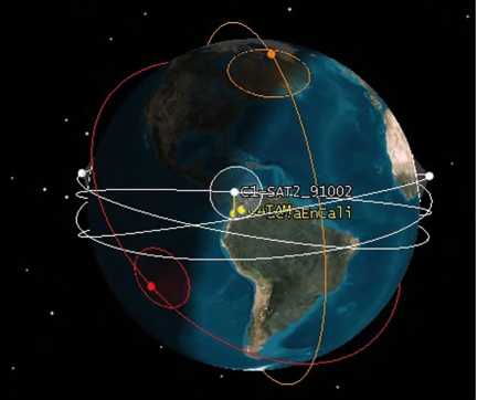
Figure 13. Third multipurpose constellations.
Source: authors.
Heterogeneous Formation
Multi-agent Systems Mission (SMA2). Homogeneous or hybrid-cluster-type in formations, proposed under the name of "Gules," associated with the groups of paratroopers from the Águilas de Gules of the Colombian Air Force. In this case, the equipment would carry out the capture of multi-objective images with super-resolution by means of groups of satellites with hybrid systems of multi or hyperspectral equipment or SAR for interferometry and 3D elevation models with formation control and leader changes.
For this particular case, it is stated as a formation of a group of five 3U satellites spaced a certain distance from each other. One observation will be carried out with RGB camera, two with multispectral camera, and the last two with hyperspectral.
This constellation is thought to have a hexagon-like formation (5 satellites) so that all satellites can look at the same location, at the same time, and almost at the same angle. But there must be a minimum distance between them, called a security distance, that is typically 65 km. Consequently, a MATLAB script is used to accomplish this. The inputs for this script are as shown:
- Inclination = 5°
- Altitude = 450 km
- Distance between satellites = 65 km
- Number of satellites = 5
Apart from the inputs, the rest of the information required to fully describe a satellite using TLE data is the same as in the FACSAT1 currently orbiting the Earth.
The script did the following in a sequential order:
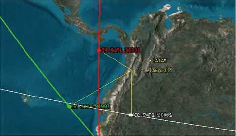
- The TLE constellation file was created using the most recent TLE information about the FACSAT1 as the central point of the constellation (red central cross in figure 14).
Source: authors.
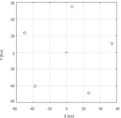
- To create the hexagon, two vectors were created in MATLAB workspace: one representing the distances along the vertical axis (Y) and another one representing the distances along the horizontal axis (X).The first result is a hexagon, as shown in figure 14.
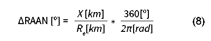
- The RAAN was taken into account to separate two satellites along the axis X in figure 14. A conversion from distance (km) to angular separation between orbits for satellites of the same constellation was made using the following equation:
- The orbital speed is required to make the conversion and calculate the right spacing along the horizontal axis between satellites. Therefore, these data is obtained
The second result is a TLE file containing the information required to describe the satellite formation shown in figure 15.
Figure 15. Heterogeneous payloads in formation.
Source: authors.
Note. This procedure, or script, is only valid if the inclination of the constellation is between 80 and 90 degrees, that is, polar constellations. To create a more general script, a more complete and complex conversion method is needed, although formations on lower inclinations only retain its form for some weeks and are not useful in the long run.
Multiple Cluster
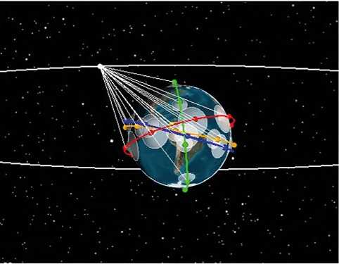
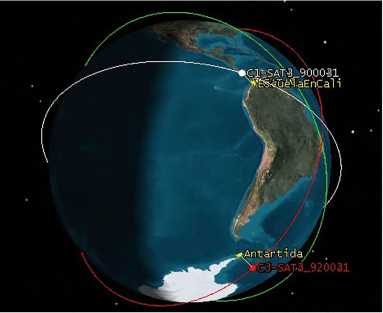
Cluster configurations are made up of groups of satellites in formation located in different orbital positions or planes, which can have homogeneous or heterogeneous payloads and different control architectures, such as distributed, hierarchical or centralized, depending on the mission to be carried out. Using the heterogeneous formation presented in the previous section as point of reference regarding one of the different groups of satellites that make up the cluster, three clusters with 5 satellites each were modeled. In the first case, as shown in figure 16, the three clusters are evenly distributed in the same orbital plane. In the second case, three groups of independent satellites are designed, where each one is configured in its own orbital plane as shown in figure 18, in addition to having different temporal resolutions and consequently a revisit frequency in different time ranges that offers many possibilities for this configuration. There are two different configurations, the first one with the synchronous clusters, as shown in figure 17, and the other is asynchronous, with which it is possible to think of different operational modes such as that illustrated in figure 18, where cluster 1 is linked to the ground station in Cali (Colombia) while cluster 3 is linked to Antarctica, where it is expected to have a remote workstation for cooperation and research purposes with allied countries.
Figure 16. Synchronic cluster model..
Source: authors.
Figure 17. Synchronic cluster access.
Source: authors.
Figure 18. Asynchronous cluster model.
Source: authors.
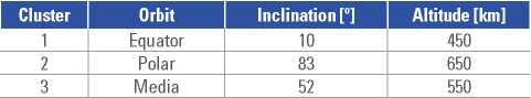
For the synchronic cluster access shown in figure 17, the satellites are in the same orbit but distanced 120° one another. As for the asynchronous cluster model shown in figure 18, the orbits for each cluster are not in the same orbit but the inclinations of each orbit are as shown in table 2. The orbits are selected based on the information in figure 7.
Tabla 2 Clusters: Inclination and altitude.
Source: authors.
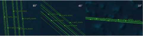
Figures 19 and 20 depict the variations suffered by a geometric configuration of 5 satellites with changes in the inclination ofthe orbital plane, showing a significant deformation in equatorial inclinations, for which it is necessary to rethink the design of the formation as well as the parameters associated with the disturbances and factors that affect these geometries.
Figure 19. Inclination and deformation cluster.
Source: authors.
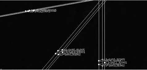
Figure 20. Synchronic Cluster with deformation geometry.
Source: authors.
These variations in geometric configuration pose the need to align the satellites in new geometries capable of maintaining the groups or clusters in each of their orbits and intersatellite distances. Evidence of these new challenges in the cooperation and coordination of satellite swarms, which can they operate together at different levels of inclination according to the mission objectives that are available for each swarm.
Multi-domain Networks
It refers to a constellation linked simultaneously with a network of several UAVs, all interconnected with each other and with ground stations. An example of this is shown in figures 21 and 22.
Figure 21. Multi-domain operations (MDO).
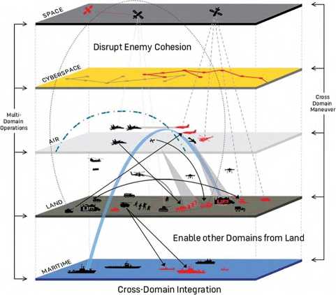
Source: US Army (2020).
Figure 22. Multidomain constellation.
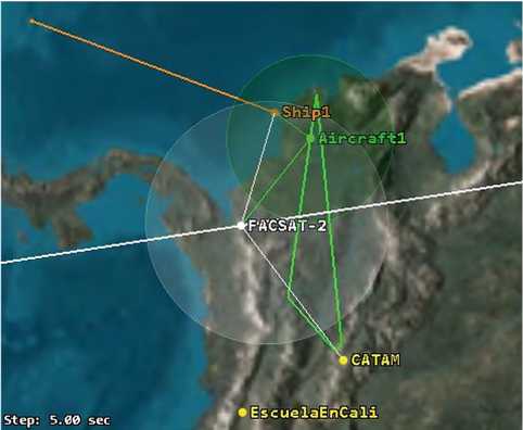
Source: authors.
The mission design for these multidomain operations, in turn, seeks the integration of information and permanent support on command-and-control activities in areas of difficult access, as well as outreach on natural resources, remote areas and populations with public needs, where integration systems provide the services demanded through equipment networks and data flow in real time.
Conclusions
Proposals for the design of networked satellite systems with different types of configurations were obtained. These were modeled with orbital elements and performance calculations for the provision of coverage, resolutions and required operational means.
Simulation models are developed for the evaluation of configurations in types of payloads, heterogeneous models in different network designs and the analysis of services such as multiband communication systems, remote sensing with optical, multi and hyperspectral systems, and even synthetic aperture radar systems. These developments offer ground evidence despite the meteorological conditions of great cloudiness that is characteristic of tropical countries such as Colombia.
Acknowledgments
This work was partially funded by the National University of Colombia and the Colombian Air Force.
Disclosures: Authors declare no institutional or personal conflicts of interest.
References
Allende-Alba, G., Montenbruck, O., Ardaens, J. S., Wermuth, M., & Hugentobler, U. (2017). Estimating maneuvers for precise relative orbit determination using GPS. Advances in Space Research, 59(1),45-62.
Álvarez, J., & Walls, B. (2016). Constellations, clusters, and communication technology: Expanding small satellite access to space. 2016 IEEE Aerospace Conference. IEEE. https://doi.org/10.1109/AERO.2016.7500896
Álvarez-Calderón, C. E., & Corredor-Gutiérrez, C. G. (eds.). (2019). El espacio exterior: Una oportunidad infinita para Colombia. el cielo no es el límite (vol. 2). Escuela Superior de Guerra. https://doi.org/10.25062/9789585245631
Bandyopadhyay, S., Subramanian, G. P., Foust, R., Morgan, D., Chung, S.-J., & Hadaegh, F. (2015). A review of impending small satellite formation flying missions. 53rd AIAA Aerospace Sciences Meeting. https://doi.org/10.2514/6.2015-1623
Barakabitze, A. A., Ahmad, A., Mijumbi, R., & Hines, A. (2020). 5G network slicing using SDN and NFV: A survey of taxonomy, architectures and future challenges. Computer Networks, 167, 106984
Bistafa, S. R. (2021). Revisiting Eulers orbital calculations for the comet of 1742. dvance in Historical Studies, 10(1), 73-92.
Burleigh, S. C., De-Cola, T., Morosi, S., Jayousi, S., Cianca, E., & Fuchs, C. (2019). From connectivity to advanced internet services: A comprehensive review of small satellites communications and networks. Wireless Communications and Mobile Computing, May, 6243505. https://doi.org/10.1155/2019/6243505
CONPES. (2020). 3983. Política de desarrollo espacial: condiciones habilitantes para el impulso de la competitividad nacional. República de Colombia - Departamento Nacional de Planeación. https://colaboracion.dnp.gov.co/ CDT/Conpes/Econ%C3%B3micos/3983.pdf
Corredor-Gutiérrez, C. G. (2017). Diseño de un marco y hoja de ruta que permita formular la política espacial de Colombia, para promover el desarrollo tecnológico, económico y social del país. Universidad de La Sabana.
Del-Portillo, I., Cameron, B. G., & Crawley, E. F. (2019). A technical comparison of three low earth orbit satellite constellation systems to provide global broadband. Acta Astronautica, 159, 123-135.
Fugmann, M., & Klinkner, S. (2020). An automated constellation design & mission analysis tool for finding the cheapest mission architecture. SSC20-I-07 Mission Architecture, 34th Annual Small Satellite Conference. SSC.
Kvell, U., Puusepp, M., Kaminski, F., Past, J. E., Palmer, K., Gro"nland, T. A., & Noorma, M. (2014). Nanosatelliitide orbiidi muutmine mikroelektromehaaniliste ku"lmgaasi to'ukemootoritega. Proceedings of the Estonian Academy of Sciences, 63(2S), 279-285.
Lansard, E., Frayssinhes, E., & Palmade, J. L. (1998). Global design of satellite constellations: A multi-criteria performance comparison of classical walker patterns and new design patterns. Acta Astronautica, 42(9), 555-564.
Lo, M. W. (1999). Satellite-constellation Design. Computing in science & engineering, 28(3), 58-67.
McDowell, J. C. (2020). The low earth orbit satellite population and impacts of the SpaceX Starlink Constellation. The Astrophysical Journal, 892(2), L36.
Mingqi, Y., Xurong, D., & Min, H. (2016). Design and simulation for hybrid LEO communication and navigation constellation. CGNCC 2016 - IEEE Chinese Guidance, Navigation and Control Conference. https://doi.org/10.1109/CGNCC.2016.7829041.
Prescornitoiu, B., & Morales, M. (2019). Estudio y diseño de constelaciones de nanosatélites en el marco de las comunicaciones loT [PhD thesis, Universidad Carlos III de Madrid]. Biblioteca Universidad Carlos III de Madrid.
Qu, Z., Zhang, G., Cao, H., & Xie, J. (2017). LEO satellite constellation for Internet of Things. IEEE Access, 5(c), 18391-18401.
Rodríguez-Pirateque, G. W. (2017). Diseño π: Gestión tecnológica para el Diseño de Proyectos de Ingeniería. Escuela de Postgrados Fuerza Aérea Colombiana.
Rodríguez-Pirateque, G. W., Cortés, G, E., & Sofrony, J. (2020). Sustainable design of low-cost modular test platforms as an entrepreneurship for space development in Colombia. 71st International Astronautical Congress (IAC), The CiberSpace Edition.
Rodríguez-Pirateque, G.-W., Sofrony Esmeral, J., Cortés García, E. D., & Rueda, K. (2020). Diseño de misión, síntesis de factores operacionales y representaciones del segmento espacial, caso FACSAT y EMFF. Ciencia y Poder Aéreo, 15(2), 143-165. https://doi.org/10.18667/cienciaypoderaereo.678
Rodríguez-Pirateque, G. W., Arzola-de-la-Peña, N., & Cortes-García, E. D. (2020). Sustainable design of a nanosatellite structure type CubeSat as a modular platform for tests. Ciencia y Poder Aéreo, 15(1), 108-134.
Roscoe, C. W., Westphal, J. J., & Mosleh, E. (2018). Overview and GNC design of the CubeSat Proximity Operations Demonstration (CPOD) mission. Acta Astronautica, 153, 410-421. https://doi.org/10.1016/j.acta astro.2018.03.033
Rouff, C., & Truszkowski , W. A. (2001). A Process for Introducing Agent Technology into Space Missions. Aerospace Conference, 2001, IEEE Proceedings, 6.
Saeed, N., Elzanaty, A., Almorad, H., Dahrouj, H., Al-Naffouri, T. Y., & Alouini, M. S. (2020). CubeSat communications: Recent advances and future challenges. IEEE Communications Surveys and Tutorials, 22(3), 1839-1862.
Schaub, H., & Junkins, J. (2009). Analytical Mechanics of Space Systems (vol. 2). AIAA Education Series.
Schilling, K. (2017). Perspectives for miniaturized, distributed, networked cooperating systems for space exploration. Robotics and Autonomous Systems, 90, 118-124.
Shahzad-Shaikh, M., Jindal, P., Mali, A., Ansari, A., & Kamble, S. (2018). Design of mems based microthruster - A study. Materials Today: Proceedings, 5(9), 20719-20726.
Soldovieri, T., & Viloria, T. (2016). El ángulo sólido y algunas de sus aplicaciones. Universidad del Zulia.
US Army. (2020). America’s ARMY: Ready now, investing in the future. https://www.army.mil/e2/downloads/rv7/about/usarmy_fy19_21_accomplishments_and_investment_ plan.pdf
Ximenes, S. W., Roberts, S. L., Lee, T. S., Shin, H. S., Foing, B., & Duarte, C. (2019). LEAP2 and LCATS industry clusters: A framework for lunar site technology development using global, space-STEM education and global space-industry development networks. Acta Astronautica, 157, 61-72.
Yoon, Z., Frese, W., Bukmaier, A., & Brieβ, K. (2014). System design of an S-band network of distributed nanosatellites. CEAS Space Journal, 6(1), 61-71.
*This work was supported by the Colombian Air Force and the National University of Colombia.