Suze Nei Pereira Guimarães4,Erick de Barros Camara 5, Igor Maurmann Guaragna6
Geophysical Innovations and Services Inc. Bogotá, Colombia
This is a comparative study on the quality of the radiometric geophysical data acquired in wet and dry conditions on semi-flat terrain. In this work, we attempted to highlight soil moisture as one of the primary factors directly influencing the gamma acquisition statistics and the airborne acquisition conditions for each case. We also highlighted the conditions of topographic altimetry that directly affect the statistical results of gamma spectrometry. It was possible to verify the elevation levels in the concentration count of uranium emanating from radium, as suggested by Charbonneau & Darnley (1970) and Grasty (1997). The values found in humid environments show a 50% increase in uranium concentrations in the atmosphere and a 50% increase in concentrations calculated by the U/K ratio, which revealed by hydrothermal zones.
Keywords: Aerial Survey, Radiometric Data, Data Processing, Soils, Radon.
El siguiente es un estudio comparativo en la calidad de la información geofísica radiométrica obtenida en condiciones h&úacute;medas y secas en terreno semiplano. En este trabajo se intentó resaltar la humedad del suelo como una de los factores primarios que influyen directamente las estadísticas de adquisición gamma y las condiciones de adquisición de vuelo para cada caso. También resaltamos las condiciones de altimetría topográfica que afectan directamente los resultados estadísticos de la espectrometría gamma. Fue posible verificar los niveles de elevación en el conteo de concentración de uranio que emanaba del radio, tal como lo sugieren Charbonneau y Darnley (1970) y Grasty (1997).Los valores encontrados en los ambientes h&úacute;medos muestran un incremento del 50 % en las concentraciones de uranio en la atmósfera y un incremento del 50 % en las concentraciones calculadas por la relación U/K, revelada por zonas hidrotérmicas.
Palabras Claves: Estudio aéreo, datos radiométricos, procesamiento de datos, suelos, radón.
O presente artigo é um estudo comparativo sobre a qualidade da informação geofísica radiométrica obtida em condições &úacute;midas e secas em terrenos semi-planos. Neste trabalho, tentou-se destacar a umidade do solo como um dos fatores primários que influenciam diretamente as estatísticas de aquisição gama e as condições de aquisição de voo para cada caso. Destacamos também as condições de altimetria topográfica que afetam diretamente os resultados estatísticos da espectrometria gama. Foi possível verificar os níveis de elevação na contagem de concentração de urânio que emanava do rádio, como é sugerido por Charbon-neau e Darnley (1970) e Grasty (1997). Os valores encontrados nos ambientes &úacute;midos mostram um aumento do 50% nas concentrações de urânio na atmosfera e um aumento do 50% nas concentrações calculadas pela relação U/K, reveladas por zonas hidrotermais.
Palavras-chave:Estudo aéreo, dados radiométricos, processamento de dados, solos, radônio.
The second half of the nineteenth century was of great importance for the study of the internal structure of atoms (Faure, 1997). Several scientists played a key role in the study of radioactivity, including Marie and Pierre Curie, Rutherford -who identified the three components of radiation, a, ß and y, as well as the proton in 1919-, Frederick Soddy -of radioactive decay-, Niels Bohr -who developed a model of the hydrogen atom-, among others.
The discovery of radioactivity was quickly followed by the study of techniques to measure this phenomenon. The first detectors were built at the beginning of the 20th century, and portable instruments were developed later. The sensitivity of the detectors increased considerably with the development of scintillometers.
Initially, the use of radioactivity in warfare greatly influenced such researchers, and a main focus was the exploration of uranium. In the 1960s and 1970s, researchers began to use radioactivity for mineral exploration and environmental monitoring.
Gamma rays (y) are the most penetrating form of radiation from natural and human-made radioactive sources. Their range power can reach heights of up to 300 m (Ferreira, 1991). Gamma-ray spectrometry is a powerful tool for monitoring and evaluating radiation in the environment. The primary sources of gamma radiation are the natural decay of potassium (40K), uranium (238U) and thorium (232Th), which are naturally present in most rocks (Cox, Bell, & Pankhurst, 1979); (Telford, Geldart, & Sheriff, 1990); (Dickin, 1995); (Faure, 1997).
Both terrestrial and aerial gamma-ray measurements can cover vast areas of the Earth's surface, and many national and regional radiometric maps have been compiled and published. The total radiation count is obtained utilizing a spectrometer (0.41-2.81 MeV). Gamma radiation in soil is inversely proportional to the density of the surrounding soil. Therefore, radiometric measurements are essentially superficial and have an average penetration depth range of 30-40 cm (Minty, 1988). The main factors that influence gamma radiation measurements include:
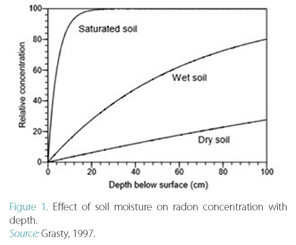
There are two components of radon (222Rn) in soils: an emanating fraction that approaches soil pores and a noneminent fraction that is trapped in soil particles. The emanating portion usually composes between 20% and 40% (Markkanen & Arvela, 1992) of the total radon concentration. Figure 1 shows the concentration of the emanating fraction with depth in the soil under three different soil moisture conditions. The concentrations were normalized to 100 arbitrary concentration units.
Given the above trends, it is recommended that data be acquired approximately three hours after the precipitation of meteoric water so that unusual surface activity is diminished and does not directly affect the acquisition of data. However, each study region has its peculiarities, as it was previously found that there is a set of variables that affect data collection. This study investigates the effects of soil moisture, atmospheric humidity, and soil variations on specific aerially collected gamma spectrometric data.
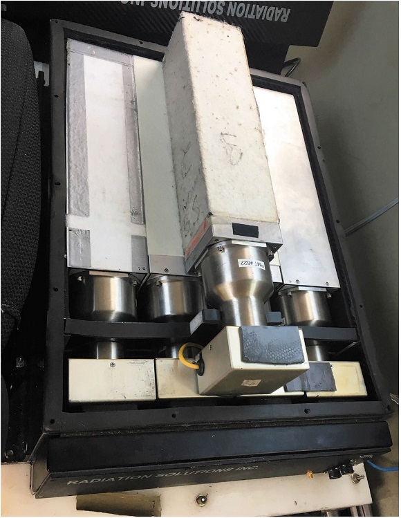
The concentration of free radon in the atmosphere is not homogeneous and may increase up to 50% in counts associated with uranium channels. To remove this effect, the downward/upward-looking configuration of radiometric detectors is used. The aircraft used in this study was equipped with a RSI-501 model air-spectrometer manufactured by Radiation Solution, Inc., as shown in Figure 2. Two data collection flights were carried out under different conditions (dry and rainy) in the same region. Both flights were made at the same speed, at the same height above the ground, with the same equipment aboard the aircraft and at the same approximate time of day.
Figure 2. Example of a Crystal Box installed in an aircraft.
Source: E. Camara, October 2016. Author's private collection
Geosoft's Oasis Montaj software was used to compile, edit and process the data acquired for the two samples. The data were then plotted and compared. After acquisition and visualization of the data, the ratios between the collected parameters were inferred, and the results were analyzed.
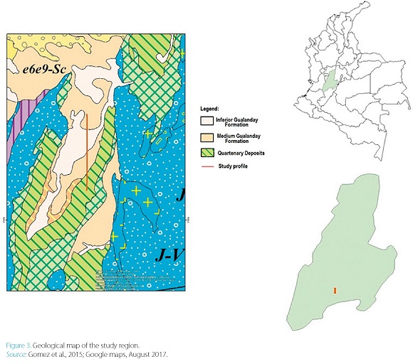
The study area is a north-south oriented profile that is 10 km long, located in the Colombian Andean region between the central and eastern mountain ranges in the Department of Tolima, Ataco Municipality (Figure 3). Previous studies (Acosta, Caro, Fuquen, & Osorno, 2002; Gomez et al., 2015) show the geological heterogeneity of the region, which is composed of metamorphic, igneous, and sedimentary geological units of marine and continental origin, as well as Quaternary deposits with different degrees of consolidation and source, with ages between the Precambrian and the Holocene, and which make up the East Flank of the Central Mountain Range and the Upper Valley of the Magdalena. In a highlight of the study area, we have the Batholith de Ibague (Nelson - 1957, 1962), which is an intrusive body of north-south orientation, and trespasses the Neises and Amphibolites of Tierradentro -the unit informally referred to as the Cretaceous Sediments without differentiating. The Honda Group covers it discordantly and is in contact with failed formations Gua-landay Inferior, Gualanday Medio and Gualanday Superior (Nuñez, 1996).
In the tectonic framework, it is affected by north-south-oriented geological structures of a regional nature, among which the Saldaña, Atá, Monte Loro, Bobón, Pole, Paipa and El Cauca faults stand out. In the municipality of Ataco two geological structures stand out, the Synclinal of Ataco and Copilicua, the first a structure of high extension and regional importance, which comes from the municipalities of Chaparral and Ortega.
The study profile encompasses the Saldaña River region, which has an essential role in the system of mass transport and or drainage. The relief is Mountainous fluvial-erosional (IGAC, 1988; Villota, 1991).
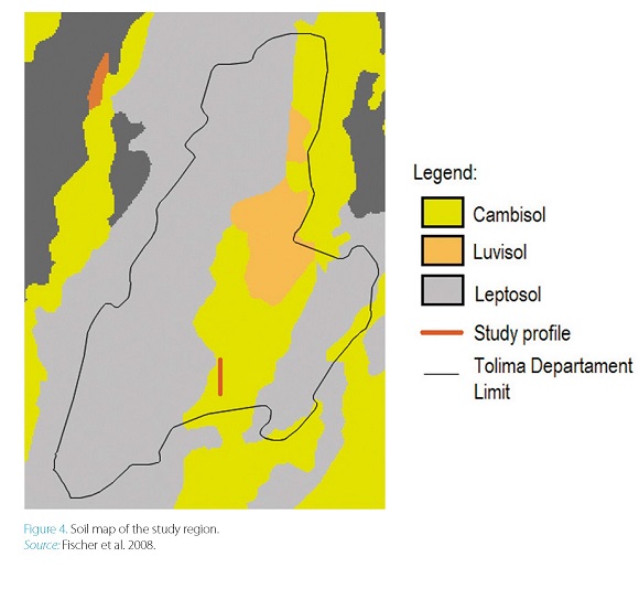
In this region, the soil is predominantly classified as Cambisol type (Fischer, Nachtergaele, Prieler, van Velthui-zen, Verelst, & Wiberg, 2008) (Figure 4). The composition of this kind of soil is generally medium-grained, is derived from a wide range of rocks, and is mainly found in alluvial, colluvial and wind deposits.
In the physiographic analysis of the municipality of Ataco allowed to define four climatic zones: Warm semiarid, Warm semi-humid, Temperate semi-arid, Temperate semi-humid and semi-humid cold (Villota, 1991).
Because the climate generally is a temperate climate, this soil is rich in nutrients and is conducive to agriculture. Regarding the primary natural radionuclides that are present in this soil, the distribution of potassium shows significant spatial variability, uranium concentrations are very low, and thorium has a homogeneous distribution throughout the study area (Chesworth, 2008).
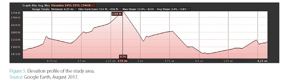
The location and altimetric profile of the acquisition line (Figure 5) show that the region consists of a sedimentary transport zone (river) and a small city (Ataco), as well as a high topographic area along the northern part of the profile. This area was chosen precisely to observe how gamma spectrometric measurements vary in high-humidity and dry conditions.
The acquisition of aerogeophysical data presented technical difficulties due to significant topographic/al-timetric variation in the study area (Figure 5). In such an environment, it is difficult to maintain the quality of the required acquisition parameters. The pilot should always be aware of the variations in the airplane axes (X, Y, and Z), aircraft speed (<280 km/h), lateral deviations from the set course and altimetric section compared to the stipulated drape (for altimetric flight and acquisition quality, approximately 100 meters from the height of the terrain) to ensure that there is no loss in resolution of the data acquired.
In addition, according to IDEAM (Institute of Hydrology, Meteorology and Environmental Studies of Colombia), average yearly rainfall in the study region reaches 1700 mm, with humidity between 65% and 83% and a high index of severe weather, which results in few opportunities for research flights.
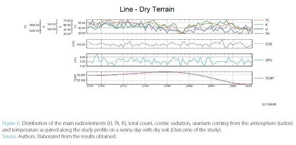
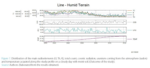
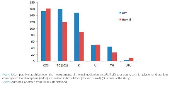
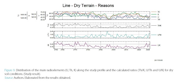
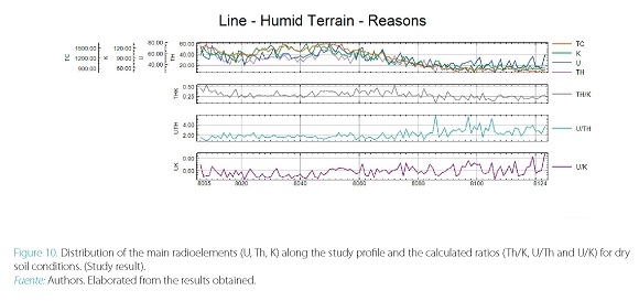
The two terrain conditions (wet and dry) showed variable results, especially regarding the degree of uncertainty, which was much higher for wet soil conditions (Figures 6 and 7). The distribution of the counts for the dry soil was smoother, showing a tendency for movement of the sources for the lower elevation part of the study site (the river) due to trends in local weathering, which is shown more clearly in the measurements of K and Th. In the profile of the counts in the wet soil, similar movement is not clear and the distribution of the measures is much more variable. In the Uranium Up profile that is related to the measurements of radon from the atmosphere, the values are widely attenuated in moist soil. The graph in Figure 8 displays the measured values for the two situations.
From the individual counts of the radioelements, it is possible to calculate the ratios between them. The ratios are used to highlight the differences observed between the concentrations of the radioactive elements for different geological phenomena, such as the presence of granite bodies in the region or strong hydrothermal alteration of potassic minerals and/or silica type, which are results of the local geology, enrichment processes and degree of weathering. In studying the effects of moisture on the measurements, we observe only intermediate variations in the results.
Figures 9 and 10 show that all ratios calculated for wet ticular, the ratio of uranium to potassium (U/K) increases its soil measurements are higher than those for dry soils. In par- value by 50%.
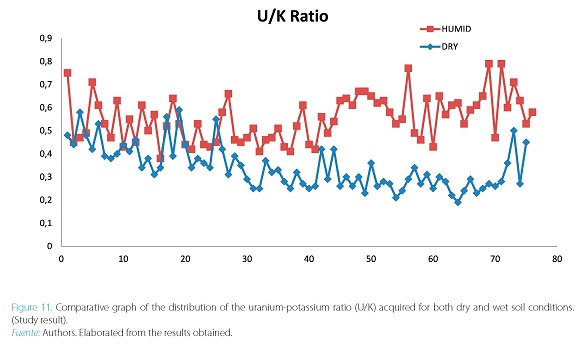
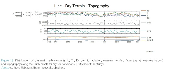
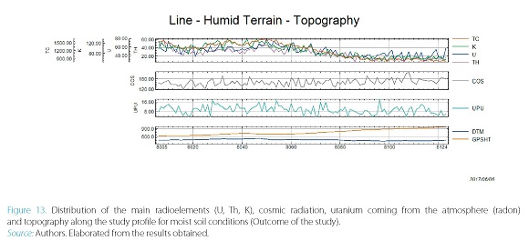
Note that the difference in the uranium-potassium ratio (U/K; Figure 11) also reveals the incoherence associated with the altimetric trend along the study profile. Figures 12 and 13 show the altimetric values for the abovementioned profile.
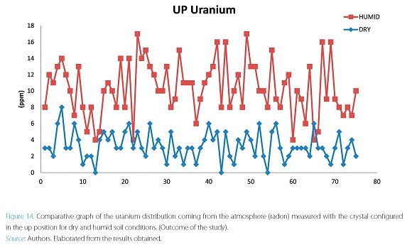
Variations in radon from the atmosphere are also revealed in the crystal measurements that were acquired with the instrument set up in the up position. In this configuration, we measured the so-called “UP Uranium” concentration.
Figure 14 is a comparison of these measurements for the two cases. As already mentioned, the results revealed a 50% increase in the measurements that directly affect the count of the uranium that emanates from the rocks of the studied surface.
Radiometric measurements acquired via gamma-spectro-metric aerial surveys have already been widely disseminated in the literature (Hood & Ward, 1969; Coyle, Dumont, Keating, Kiss & Miles, 2014; Camara & Guimarães, 2016) for use in mineral prospecting, environmental monitoring and geological mapping. However, the controls used in the acquisition of such data can directly influence the results, interpretations, and statistics, which means that the data must be carefully adjusted during data processing to ensure total reliability.
In this work, it was demonstrated that soil moisture directly influences the gamma-spectrometric measurements, drastically altering the interpretation of soil weathering. In this case, the information gathered from the lower part of the study profile (occupied by a river) with moist soil did not follow this trend.
The concentration of radon from the atmosphere increased by 50%, demonstrating that uranium measurements were directly affected by soil moisture content.
Finally, the observations that have been made by several authors regarding the non-efficacy of aerial radiometric measurements in moist soil are validated, and it is recommended that researchers wait 3-4 hours following a precipitation event for anomalous surface activity to disintegrate in order to not affect gamma-spectrometric measurements.
However, some important variables must also be considered. The soil type is one of the primary variables, in addition to the geological setting of the study area. In regional aero-surveying, it is not possible to control rainfall or residual soil moisture content. In these cases, the best methods are to cross-reference geological information and joint interpretations to correct the radiometric data.
The ratio of uranium to potassium (U/K), which reveals hydrothermal zones, was affected by soil moisture, causing uncertainty in the comparison of locations with ups and downs.
The database discussed in the present paper was acquired during the Project Survey of Magnetometry and Gamma Spectrometry in Colombia - ANDES-C (2016) by SGC (Servicio Geológico Colombiano). We acknowledge the authorization of using this database. We also acknowledge all group of acquisition airborne (crew and technical operator) by clarifying specifications of control data.
Acosta, J. G., Caro, P. E., Fuquen, J. A., & Osorno, J. F. (2002). Geologia de la plancha 303. Bogota: Ingeominas.
Camara, E. d., & Guimarães, S. N. (2016). Magnetic airborne survey -geophysical flight. Geoscientific Instrumentation, Methods and Data Systems, 5, 181-192.
Charbonneau, B. W., & Darnley, A. G. (1970). A test strip for calibration of airborne gamma-ray spectrometers: in Report of Activities. Geological Survey of Canada, 70(1), 27-32.
Chesworth, W. (2008). Encyclopedia of Soil Science (Vol. 1). Netherlands: Springer.
Cox, K. G., Bell, J. D., & Pankhurst, R. J. (1979). The interpretation of igneous rocks. London: George Allen & Unuwin.
Coyle, M., Dumont, R., Keating, P., Kiss, F., & Miles, W. (2014). Geological Survey of Canada aeromagnetic surveys: design, quality assurance, and data dissemination. Geological Survey of Canada, Open File 7660. doi:10.4095/295088
Dickin, A. D. (1995). Radiogenic Isotope Geology. Cambridge: Cambridge University Press.
Faure, G. (1997). Principles and applications of geochemistry. New York: Prentice Hall.
Ferreira, F. J. (1991). Aerogamaespectrometria E Aeromagnetometria De Um Trato Ocidental Do Pré-cambriano Paulista (Tesis doctoral). Universidade de São Paulo. Instituto de Geociências, Brasil.
Fischer, G., Nachtergaele, F., Prieler, S., van Velthuizen, H. T., Verelst, L., & Wiberg, D. (2008). Global Agro-ecological Zones. Assessment for Agriculture (GAEZ 2008). IIASA, Laxenburg, Austria and FAO, Rome, Italy.
Instituto Geográfico Agustín Codazzi, 1988. Suelos y bosques de Colombia. Bogotá: IGAC.
Gomez, J., Nivia, A., Montes, N. E., Almanza, M. F., Alcarcel, F. A., & Madrid, C. A. (2015). Notas explicativas: Mapa Geológico de Colombia. Compilando la geología de Colombia: Una Visión a 2015. 9-33.
Grasty, R. L. (1997). Radon emanation and soil moisture effects on airborne gamma ray measurements. Geophysics, 62(5), 1379-1385.
Hood, P., & Ward, S. H. (1969). Airborne Geophysical Methods. Geological Survey of Canada, 13, 1-112.
Nelson, H.W. (1957). Contribution to the geology of the Central and Western Cordilleras of Colombia in the sector between Ibagué and Cali. Leidse Geology Mededelingen, Volumen 22: 1-75. Leinden.
NELSON, H.W. (1962). Contribución al conocimiento de la Cordillera Central de Colombia, sección entre Ibagué-Armenia. Boletín Geológico, Servicio Geológico Nacional, Volumen 10, N° 1-3: 161-202. Bogotá: SGN.
Núñez, A. (1996). Mapa Geológico del Departamento del Tolima. Informe 2195. Ibagué: Ingeominas.
Markkanen, M., & Arvela, H. (1992). Radon emanation from soils. Radiation Protection Dosimetry, 45 (1/4), 269-272.
Minty, B. R. (1988). A review of airborne gamma-ray spectro- metric data-processing techniques. Canberra: Australian Gov. Publ. Service, 48.
Telford, W. M., Geldart, L. P., & Sheriff, R. E. (1990). Applied geophysics (Vol. 2nd). New York: Cambridge University.
Villota, H. (1991). Geomorfología aplicada a levantamientos edafológi-cos y zonificación física de las tierras. Primera parte: Geomorfolo-gía de zonas montañosas, colinadas y onduladas. Bogotá: IGAC.